Skip to content

Agios Stefanos · Quick navigation

Agios Stefanos weather: 14-day forecast, hourly meteogram, 850 hPa and precipitation ensembles, satellite imagery and station records.

Northern Athens & northern Attica webcams

Choose a camera · Northern Attica

Images load as you approach them. A retrieval time confirms a download, not a new camera frame. Source links remain available when an image cannot load.

Weather webcams from Agios Stefanos, Mount Parnitha and other parts of Northern Attica show cloud cover, visibility and changing rain or snow conditions where these are visible. Cameras differ in elevation, viewing direction and update frequency, so check the image timestamp. Compare the view with local weather station observations.

Agios Stefanos webcam · 380 m

Open the camera on YouTube ↗
If the player remains blank, open the source. The weather timestamp refers to station measurements, not to the video frame.

Station observationsWeatherLink · Davis

Observed · Greece time — · —

Loading Agios Stefanos observations…

Temperature

— °C

Daily high / low

High
— °C · —
Low
— °C · —

Wind

— —

Direction —

Gust today
— — · —
Wind chill
— °C

Rain today

— —

Today’s total

Peak rate
— — · —
Current rain event
— —
Month
— —
Year
— —

Humidity

— —
Daily high
— — · —
Daily low
— — · —
Dew point
— °C

Pressure

— —

—

Daily high
— — · —
Daily low
— — · —

Feels like / daylight

Heat index
— °C
THW
— °C
Sunrise
—
Sunset
—
Kouremenou Hill and Forest (Antenna) · elevation 380 m
The camera faces south towards Mount Penteli, with Dionysos, Rea Drosia and Ekali from left to right (east to west), and Anixi and Drosia between the camera and the mountain.
Northern Athens suburbs, northern Attica, Municipality of Dionysos: Agios Stefanos, Anixi, Drosia, Dionysos, Kryoneri, Rea Drosia, Rodopoli and Stamata
Agios Stefanos Webcam, Northern Athens, Northern Attica, Northern Suburbs Athens, Dionysos Municipality, Agios Stefanos Weather Station
4K Hikvision DS-2CD2T86G2-2I4C camera

Agios Stefanos motorway webcam · 360 m

Agios Stefanos motorway webcam · 360 m
Agios Stefanos motorway webcam · 360 m · Open image at source ↗

Source: https://www.forecastweather.gr/

Mount Parnitha webcams · 1,100–1,200 m

Bafi mountain refuge

Bafi mountain refuge
Bafi mountain refuge · Open image at source ↗


Bafi mountain refuge
Bafi mountain refuge · view 2 · Open image at source ↗

Flambouri mountain refuge

Flambouri mountain refuge
Flambouri mountain refuge · Open image at source ↗

Source: https://www.forecastweather.gr/

Ippokrateios Politeia webcam · 600 m

Ippokrateios Politeia webcam · 600 m
Ippokrateios Politeia webcam · 600 m · Open image at source ↗


Ippokrateios Politeia webcam · 600 m
Ippokrateios Politeia webcam · 600 m · view 2 · Open image at source ↗

Source: https://www.forecastweather.gr/

Anixi webcam · 400 m

Anixi webcam · 400 m
Anixi webcam · 400 m · Open image at source ↗


Anixi webcam · 400 m
Anixi webcam · 400 m · view 2 · Open image at source ↗

Source: https://www.forecastweather.gr/

Dionysos webcam · 500 m

Dionysos webcam · 500 m
Dionysos webcam · 500 m · Open image at source ↗

Source: http://dionysos-penteli.meteoclub.gr/

Rea Drosia webcam · 450 m

Rea Drosia webcam · 450 m
Rea Drosia webcam · 450 m · Open image at source ↗

Source: http://reaweather.gr/

Drosia webcam · 400 m — YouTube live

Live stream by Fotis Karayannis. The photo from the same camera follows below. Open on YouTube ↗

Drosia webcam · 400 m

Drosia webcam · 400 m
Drosia webcam · 400 m · Open image at source ↗

Source: https://penteli.meteo.gr/stations/drosia/

Drosia webcam · 390 m

Drosia webcam · 390 m
Drosia webcam · 390 m · Open image at source ↗

Source: https://www.pefteixioni.com/

Penteli Observatory webcam · 500 m, Palaia Penteli

Penteli Observatory webcam · 500 m, Palaia Penteli
Penteli Observatory webcam · 500 m, Palaia Penteli · Open image at source ↗


Penteli Observatory webcam · 500 m, Palaia Penteli
Penteli Observatory webcam · 500 m, Palaia Penteli · view 2 · Open image at source ↗


Penteli Observatory webcam · 500 m, Palaia Penteli
Penteli Observatory webcam · 500 m, Palaia Penteli · view 3 · Open image at source ↗

Source: https://www.meteo.gr/

Kifisia webcam · 290 m

Kifisia webcam · 290 m
Kifisia webcam · 290 m · Open image at source ↗

Source: https://kifissiameteo.gr/

Acharnes webcam · 210 m

Acharnes webcam · 210 m
Acharnes webcam · 210 m · Open image at source ↗

Source: https://www.meteoacharnes.gr/

Fyli webcam · 350 m

Fyli webcam · 350 m
Fyli webcam · 350 m · Open image at source ↗

Source: http://fyli.meteoclub.gr/

Markopoulo Oropou webcam · 300 m

Markopoulo Oropou webcam · 300 m
Markopoulo Oropou webcam · 300 m · Open image at source ↗


Markopoulo Oropou webcam · 300 m
Markopoulo Oropou webcam · 300 m · view 2 · Open image at source ↗

Source: https://markopoulo-oropos.meteoclub.gr/

Ano Dioni, Pikermi webcam · 342 m

Ano Dioni, Pikermi webcam · 342 m
Ano Dioni, Pikermi webcam · 342 m · Open image at source ↗

Source: https://anodioni-pikermi.meteoclub.gr/

Rafina webcam

Rafina webcam
Rafina webcam · Open image at source ↗

Source: https://www.forecastweather.gr/

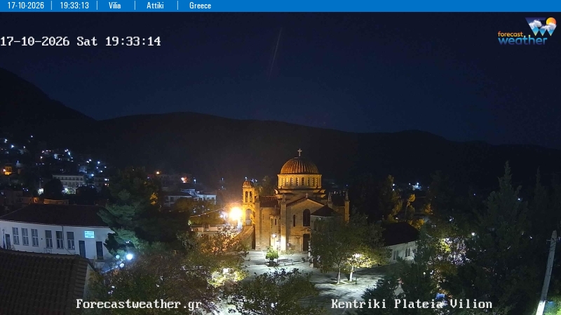
Vilia webcam · 535 m

Vilia webcam · 535 m
Vilia webcam · 535 m · Open image at source ↗

Vilia central square

Vilia central square
Vilia central square · Open image at source ↗

Source: https://www.forecastweather.gr/

Forecast sources and model coverage

Forecast source

The choice applies to widgets, maps and forecasts. Actual station readings stay unchanged. Automatic tries Open-Meteo first, then available direct sources if a supported request fails.

Open-Meteo

Data service providing forecasts from NOAA, ECMWF, ECCC, DWD, the Met Office, Météo-France and JMA. Available models, variables and grids depend on the location and product.

Direct model sources

XIONIA collects data directly from the model providers. Forecasts and maps are served after the source cycle has been published and collected. The selected product shows its model, resolution, available variables and run.

How models combine

Each available family contributes once per variable. Direct forecasts select the freshest available GFS grid and use equal family weights as the baseline. Local weights apply only where enabled after validation. The comparison shows actual percentages and model cycles.

Additional model forecasts are also shown for comparison and backtesting. Their presence does not automatically add weight to the combined forecast; check the displayed weights.

Coverage and missing values

A dash means unavailable data. Wind and gust may use different models. AIGFS temperature is excluded when it cannot be compared on the same elevation basis. Six-hour precipitation is water equivalent, not snow depth.

Time window

A “Today” label with hours in parentheses covers only the stated time window; subsequent days require full local coverage. Days 8–14 are a less certain outlook. Agreement between models is not a probability from a true ensemble.

Ensemble forecasts

Ensemble systems provide multiple forecast scenarios; the available systems appear in the chart selector and image catalogue. AIGFS is the single forecast; AIGEFS is the separate ensemble. Available variables and forecast horizons differ by system.

Open-Meteo · NOAA · ECMWF Open Data · ECCC Open Data · DWD / ICON · Met Office / UKMO · Météo-France / ARPEGE · JMA