Kouremenou Hill and Forest (Antenna) · Elevation 380 m
Live weather from Northern Attica
Live local weather from Kouremenou Hill and Forest in Agios Stefanos, Attica. Station owner and observer: Alkis Sarantopoulos, since 2008. Measurements refresh every minute. The camera faces south towards Mount Penteli.
Agios Stefanos · Quick navigation
Agios Stefanos weather: 14-day forecast, hourly meteogram, 850 hPa and precipitation ensembles, satellite imagery and station records.
Station forecast based on barometric pressure
Increasing clouds with little temperature change.
Kouremenou Hill and Forest (Antenna) · Elevation 380 m
The camera faces south towards Mount Penteli. From left to right are Dionysos, Rea Drosia and Ekali, with Anoixi and Drosia between the station and the mountain.
Northern Attica, Dionysos Municipality: Agios Stefanos, Anoixi, Drosia, Dionysos, Kryoneri, Rea Drosia, Rodopoli and Stamata.
Agios Stefanos weather station webcam, northern suburbs of Athens.
4K camera: Hikvision DS-2CD2T86G2-2I4C
Station observations · Local time in Greece
Current weather at Agios Stefanos,
Attiki
Select any graph to enlarge it.
Temperature & humidity
⤢TemperatureOutdoor sensor · °C⤢Relative humidityOutdoor sensor · %⤢Dew pointDew-point temperature · °C
Some records from before 2015 were lost or corrupted following a hard drive failure.
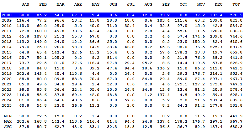
Yearly and monthly precipitation
Weather station upgrades
November 2018:
New temperature and humidity sensor. Rain gauge calibration, with an estimated previous undercatch of 18%.
October 2024:
New fan for the temperature and humidity sensor's daytime fan-aspirated radiation shield.
New AeroCone rain collector. New solar panel.
November 2025:
New WeatherLink data logger and WeatherLink Envoy. In October 2025 the logger failed and the console stopped for 2 days; it recovered after being unplugged for 1 hour. Minimum and maximum temperatures, precipitation and peak wind gusts remain available for the period without a logger.
Agios Stefanos weather station records since 2008
❄️ Lowest temperature:
-6.4 °C on 18 February 2008
🔥 Highest temperature:
43.8 °C on 23 July 2023
💧 Highest daily rainfall:
147.4 mm on 21 January 2026
136 mm on 1 April 2026
134.6 mm on 14 December 2020
125-135 mm on 30 December 2012
108.2 mm on 14 October 2021
87.6 mm on 22 October 2015
77 mm on 4 December 2025
76.8 mm on 11 December 2009
75 mm on 29 September 2018
71.2 mm on 6 December 2024
70.8 mm on 26 January 2023
70 mm on 3 February 2011
70-80 mm on 22 February 2013
65.6 mm on 30 December 2019
62.6 mm on 12 December 2014
💧 Highest storm rainfall:
235 mm 10-16 December 2020
169.6 mm 6-12 December 2014
169.4 mm 1-5 April 2026
162 mm 21-23 January 2026
150-160 mm 29-31 December 2012
140.2 mm 22-24 October 2015
136 mm 29 Sep - 1 Oct 2018
131.4 mm 23-29 December 2024
131 mm 14-15 October 2021
126.2 mm 4-5 December 2025
123.2 mm 10-13 December 2009
⛈️ Highest rain rate:
960 mm/h on 4 July 2024
🌧 Highest monthly rainfall:
297.1 mm in December 2020
☔ Average annual precipitation since 2008:
685.3 mm
💨 Highest wind speed:
82.1 km/h, WSW on 16 January 2016
Climatological data and Agios Stefanos station archive
Agios Stefanos · Weather history
Snow in Northern Attica · 2019 video archive
Two videos from 7 and 8 January 2019. Explore the 2019 snow history.
The choice applies to widgets, maps and forecasts. Actual station readings stay unchanged. Automatic tries Open-Meteo first, then available direct sources if a supported request fails.
Open-Meteo
Data service providing forecasts from NOAA, ECMWF, ECCC, DWD, the Met Office, Météo-France and JMA. Available models, variables and grids depend on the location and product.
Direct model sources
XIONIA collects data directly from the model providers. Forecasts and maps are served after the source cycle has been published and collected. The selected product shows its model, resolution, available variables and run.
How models combine
Each available family contributes once per variable. Direct forecasts select the freshest available GFS grid and use equal family weights as the baseline. Local weights apply only where enabled after validation. The comparison shows actual percentages and model cycles.
Additional model forecasts are also shown for comparison and backtesting. Their presence does not automatically add weight to the combined forecast; check the displayed weights.
Coverage and missing values
A dash means unavailable data. Wind and gust may use different models. AIGFS temperature is excluded when it cannot be compared on the same elevation basis. Six-hour precipitation is water equivalent, not snow depth.
Time window
A “Today” label with hours in parentheses covers only the stated time window; subsequent days require full local coverage. Days 8–14 are a less certain outlook. Agreement between models is not a probability from a true ensemble.
Ensemble forecasts
Ensemble systems provide multiple forecast scenarios; the available systems appear in the chart selector and image catalogue. AIGFS is the single forecast; AIGEFS is the separate ensemble. Available variables and forecast horizons differ by system.